TModeling
Start of topic | Skip to actions
 We have the following raw data, thanks to NAVAIR
- Video in "/playpen/geo_star/china lake video" on phidias
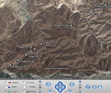
- 1:09 video (mpeg & raw).
- The flight path is roughly from 34:24:25N, 118:22:40W to 34:25:40N, 118:20:13. See gps track: gpsforVNtoCL0003.txt
- If you use Google Earth, you can get these placemarks: ChinaLakeVideo3.kmz
- Agua Dulce geo tiff imagery (aquadulce4.tif contains the path) at about 1m/pixel
- 1:09 video (mpeg & raw).
- elevation data in "/playpen/geo_star/china lake data"
- DTED (w119/n34.dt2 contains the path)
- 1:24,000-Scale Raster Profile Digital Elevation Mode (STDS format) LAT:: 34 22 30.0000, N LONG:: -118 15 0.0000
- Elevation
- SRTM 1arcsec elevation data
- NED 1arcsec elevation data
- NED 1/3arcsec elevation data
- Imagery
- Landsat thematic mapper imagery 3 bands at 1arcsec
- Digital Ortho quarter Quad imagery, 1m/pixel
- DRG 24k map image, 1m/pixel
- cl_elev.zip: Clipped UTM for china lake video VNtoCL0003?
- A tutorial introduction to Universal Transverse Mercator (UTM) coordinates (focussed on their use with GPS) http://www.maptools.com/UsingUTM/
| rastert_clxxx | ncols | nrows | xllcorner | yllcorner | cellsize |
| dted1.txt | 131 | 82 | 373400 | 3808200 | 28.197268054047 |
| ned1.txt | 133 | 83 | 373400 | 3808200 | 27.716048553091 |
| srtm1.txt | 133 | 83 | 373400 | 3808200 | 27.716064167709 |
| dem1.txt | 370 | 230 | 373400 | 3808200 | 9.9985626621209 |
| ned3.txt | 401 | 249 | 373400 | 3808200 | 9.2235465283486 |
| ls11.txt | 134 | 83 | 373400 | 3808200 | 27.715232431149 |
| ls21.txt | 134 | 83 | 373400 | 3808200 | 27.630001901861 |
| ls31.txt | 134 | 83 | 373400 | 3808200 | 27.630001901861 |
| aquad1.txt | 3700 | 2300 | 373400 | 3808200 | 0.99997808844397 |
| doqq1.txt | 3700 | 2300 | 373400 | 3808200 | 0.99999985399996 |
| drg241.txt | 3700 | 2300 | 373400 | 3808200 | 0.99999992099992 |
| rastert_clxxx | ncols | nrows | xllcorner | yllcorner | cellsize |
to top
| I | Attachment  | Action  | Size | Date | Who | Comment |
|---|---|---|---|---|---|---|
| | ChinaLakeVideo3.kmz | manage | 1.5 K | 14 Jan 2006 - 23:05 | JackSnoeyink | Google Earth Placemarks |
| | gpsforVNtoCL0003.txt | manage | 5.4 K | 14 Jan 2006 - 23:34 | JackSnoeyink | approximate segment of gps track of flight during video |
| | cl_elev.zip | manage | 782.1 K | 16 Jan 2006 - 19:19 | JackSnoeyink | Clipped UTM for china lake video VNtoCL0003? |
Edit | Attach image or document | Printable version | Raw text | More topic actions
Revisions: | r1.3 | > | r1.2 | > | r1.1 | Total page history | Backlinks
Revisions: | r1.3 | > | r1.2 | > | r1.1 | Total page history | Backlinks