TModeling
Start of topic | Skip to actions
I would like us to collect research project descriptions here, and when someone takes over a research project, they can create a WikiWord for it and give it its own webpage.
to top
Wavelet representations
One dimensional
Wenjie created a MATLAB implementation of his results on OneDWavelets. This is a possibility to serve as the basis for a tensor product surface. (See below)Two dimensional
Here are the mathematical steps that are needed: (To be completed)Terrain modeling
Interpolation
Some philosophical babbling about terrain surface modeling for GIS.
-- YuanxinLiu - 19 Apr 2005SubdivisionSurfaces
Charles has a new method for interpolatory SubdivisionSurfaces -- JackSnoeyink - 07 Feb 2006Simplex Splines
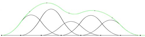
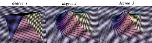
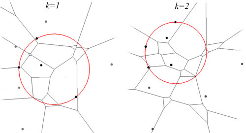
SimplexSplines generalize the familiar B-splines in one dimension that can accomodate irregularly spaced knots. Recent work of Neamtu[1] shows a way of knot set selection based on high order Voronoi diagrams. We would like to use simplex splines for constructing terrain surface, which means that we have to deal with interpolation and with possible high complexity of the kth order Voronoi. One difficult question is what knot sets to use. There are several goals:- The distribution of knots should mimic the distribution of the input points. That is, where the input points are dense, so should the knots be.
- If we try to interpolate some input points, then these points should be located near the maximals of the basis functions. Otherwise, the resulting surface will have "ripples".
Tensor product splines
There are simple ways to extend one-dimensional results to two dimensions, which is how we will begin Leonard has a brief powerpoint presentation on using TerrainRepsFromSVD -- using Singular Value Decomposition to represent terrain as a sum of vector product surfaces. We can do the same with 1-d splines.Importance orderings for points
VeryImportantPoint (VIP) heuristics are common ways to construct piecewise linear representations of terrain. They will be important for a simplex spline representation and for wavelet analysis, as well, so I'd like suggestions for how to compute PointImportanceOrders for different applications.Simplification that preserves usability for applications
Finding feature points for image matching
Fast image matching
Shortest paths on terrain models
Sack and Lanthier have a series of papers on ShortestPaths on TINs.Traversability/trafficability of terrain models
Representations for traversability that accurately capture both height and slope should be one of our first targets. ZachBailey has commented on SlopeInTensorProductMatrices.Visibility on terrain models
ViewShed computation is difficult on large terrain because it is not a local operation. Some ideas are those of Stewart.Gravity modeling
GravityModeling? is of interest to NGA, and they have provided data and procedural manuals after the GravityMeetingSept05.Database queries
Find me terrain that looks like this...
Miscellaneous geometric computations for GIS
It is easier for me to begin to populate this wiki by reporting on work that is ongoing, even though it may not all be in the scope of the DARPA project. One example is SimpSimp -- Craig Falls' work on line simplification that preserves simplicity. See also Marc's question on CountingAnisoDelaunay.Streaming meshes
Martin Isenburg had developed the idea of a streaming representation of a polygonal mesh, where the vertices and edges are stored intermixed and each vertex is explicitly finalized and freed after its last reference. One can perform traversal-based computations on a mesh by keeping only the boundary of the traversed region in memory. We are writing a paper on StreamingCompression. I would like to have someone work on StreamingDelaunay -- applying the streaming ideas to compute Delaunay triangulations of large point sets. Preprocessing points by a space-filling curve, such as the HilbertOrder?, seems to be very helpful for computing large Delaunay tessellations fast, even in higher dimensions.Filters for digital terrain models
Digital terrain models, as opposed to digital surface models, are supposed to include terrain points only; building and vegitation should be removed. This is not easy, but it would be nice to see how well we can do with simple streaming filters. TerrainFilters?code updates in svn
SVNUpdates? Just needed a place to put updates for code in our svn repository. -- JackSnoeyink - 23 Feb 2005to top
| I | Attachment  | Action  | Size | Date | Who | Comment |
|---|---|---|---|---|---|---|
| | bspline.jpg | manage | 10.3 K | 07 Feb 2005 - 05:13 | YuanxinLiu | b-spline |
| | simplexspline.jpg | manage | 34.7 K | 07 Feb 2005 - 05:10 | YuanxinLiu | simplex spline |
| | voronoi.jpg | manage | 18.0 K | 07 Feb 2005 - 08:00 | YuanxinLiu | |
| | complex.jpg | manage | 6.7 K | 07 Feb 2005 - 08:01 | YuanxinLiu | |
| | aurenhammer-kvoronoi.pdf | manage | 1050.6 K | 07 Feb 2005 - 22:46 | YuanxinLiu | aurenhammer's voronoi algorithm |
| | boissonnat93semidynamic.ps | manage | 4161.8 K | 07 Feb 2005 - 22:48 | YuanxinLiu | Boissonnat's Voronoi algorithm |
| | UNC-UMSL-GEO-quad-mar05.ppt | manage | 265.0 K | 28 Mar 2005 - 15:10 | JackSnoeyink | Example quad chart |
Edit | Attach image or document | Printable version | Raw text | More topic actions
Revisions: | r1.20 | > | r1.19 | > | r1.18 | Total page history | Backlinks
Revisions: | r1.20 | > | r1.19 | > | r1.18 | Total page history | Backlinks